The following are field notes from a visit to the valley just to the W of Drystone Edge to inspect the Upper Namurian, especially the Ringinglow coal outcrop and associated seatearth and marine shales (contorted beds). The locations were logged using a Garmin GPS60, and may be downloaded in GPX format. The points are named in the format “ORC %N”, and referred to below.
ORC 001 – SK 02262 68251 – Roadside parking.
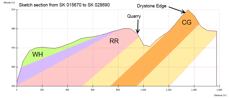
Proceed N up the road to Readyleech Green. Just past the house, the road swings NW, following a fault with downthrow on the SW side. To the right is the Upper Namurian Chatsworth Grit (CG), while the higher ground to the W of the road (Knotbury Common) is Westphalian (Coal Measures) Woodhead Hill Rock (WH). The right of way track around the S side of Knotbury Common approximately follows the lower boundary of the WH.
ORC 002 – SK 02198 69014 – Shaft Hummock. This is in the shales between the Chatsworth Grit (CG) and Rough Rock (RR). The coal sits just above the CG.
At this point you are on Open Access Land. Descend to the stream, which is easy enough if you follow the fence approx Southwards on its stream-side.
ORC 003 – SK 02170 68842 – Good clean exposure just above the stream bed of CG followed by seatearth then coal. There may be a detectable marine band here but I didn’t look. The seatearth shows interesting patterning. There is also some evidence of fossilised vegetation.
ORC 004 – SK 02330 69112 – Contorted Bed.
ORC 005 – SK 02319 69450 – Quarry in Rough Rock. Look at the texture, grain size, bedding etc to compare with CG on Drystone Edge (ORC 009). The top of the RR is the top of the Namurian; a band of marine shale with distinctive fossils marks the bottom of the Westphalian (Coal Measures).
ORC 006 – SK 02598 69608 – Contorted Beds.
ORC 007 – SK 02680 69725 – Some nice pieces of loose coal (apparently not in situ, but 5-10cm longest dimension).
ORC 008 – SK 02781 69373 – CG boulders showing Karstic features.
ORC 009 – SK 02698 69152 – Scarp exposure of CG on Drystone Edge. Look NW towards the RR quarry visited earlier and consider the section (above), which follows the same line.
A 5km x 5km square of the solid geology with a lower left corner at SK 000 650 may be obtained using the British Geological Survey map server using the link https://map.bgs.ac.uk/arcgis/services/BGS_Detailed_Geology/MapServer/WMSServer?REQUEST=GetMap&VERSION=1.3.0&LAYERS=BGS.50k.Bedrock&STYLES=default&FORMAT=image/gif&CRS=EPSG:27700&BBOX=400000,365000,405000,370000&WIDTH=500&HEIGHT=500
These are personal notes, shared for whoever may find them useful. I am not a qualified geologist; more details may be found in the Geologist Association Guide No. 26, by F. Wolverson Cope. I used this book to visit the site, although the account above contains additional sites, and more precise location for some of Cope’s sites.
Look up: upper carboniferous cyclothems.