I have written a series of field guides to mining history (and some geology and other historical notes) for selected areas in the Peak District. Each guide consists of a written field guide, maps, and digital location data for GPS devices.
The third looks at coal mining west of Buxton, specifically the area around Derbyshire Bridge in the upper Goyt Valley, above Burbage, and across to Thatch Marsh and Cisterns Clough. Version 1.0 published January 2024.
The following are field notes from a visit to the valley just to the W of Drystone Edge to inspect the Upper Namurian, especially the Ringinglow coal outcrop and associated seatearth and marine shales (contorted beds). The locations were logged using a Garmin GPS60, and may be downloaded in GPX format. The points are named in the format “ORC %N”, and referred to below.
ORC 001 – SK 02262 68251 – Roadside parking.
Proceed N up the road to Readyleech Green. Just past the house, the road swings NW, following a fault with downthrow on the SW side. To the right is the Upper Namurian Chatsworth Grit (CG), while the higher ground to the W of the road (Knotbury Common) is Westphalian (Coal Measures) Woodhead Hill Rock (WH). The right of way track around the S side of Knotbury Common approximately follows the lower boundary of the WH.
ORC 002 – SK 02198 69014 – Shaft Hummock. This is in the shales between the Chatsworth Grit (CG) and Rough Rock (RR). The coal sits just above the CG.
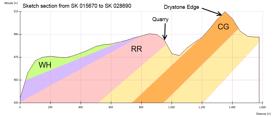
Section through Drystone Edge and Orchard Common looking North
At this point you are on Open Access Land. Descend to the stream, which is easy enough if you follow the fence approx Southwards on its stream-side.
ORC 003 – SK 02170 68842 – Good clean exposure just above the stream bed of CG followed by seatearth then coal. There may be a detectable marine band here but I didn’t look. The seatearth shows interesting patterning. There is also some evidence of fossilised vegetation.
ORC 004 – SK 02330 69112 – Contorted Bed.
ORC 005 – SK 02319 69450 – Quarry in Rough Rock. Look at the texture, grain size, bedding etc to compare with CG on Drystone Edge (ORC 009). The top of the RR is the top of the Namurian; a band of marine shale with distinctive fossils marks the bottom of the Westphalian (Coal Measures).
ORC 006 – SK 02598 69608 – Contorted Beds.
ORC 007 – SK 02680 69725 – Some nice pieces of loose coal (apparently not in situ, but 5-10cm longest dimension).
ORC 009 – SK 02698 69152 – Scarp exposure of CG on Drystone Edge. Look NW towards the RR quarry visited earlier and consider the section (above), which follows the same line.
These are personal notes, shared for whoever may find them useful. I am not a qualified geologist; more details may be found in the Geologist Association Guide No. 26, by F. Wolverson Cope. I used this book to visit the site, although the account above contains additional sites, and more precise location for some of Cope’s sites.
The download below is a GPX file suitable for GPS and digitak mapping software. The locations are of sites mentioned in the Peak District Mines and Historical Society newsletter editions 122-133. These are not sites I have GPS-located but have been transcribed from grid references in the newsletter. These are sometimes 6 figure OS Grid refs and sometimes 10 figure. They may be wrong! The comments are generally very brief and the intent is that reference is made to the appropriate newsletter, using these “waypoints” as a spatial index. The waypoint names are of the form “PD-N122-03” which means the reference is in Newsletter 122 and is the third one (generally in the “Observations and Discoveries” section).
(At present Newsletters are not on the PDMHS website but many of the old journals are. Join PDMHS!)
I’ve been struggling with scanning BGS maps and importing them into Mapyx Quo for a while. Its an arduous process and the scanned maps contain the roads, placenames etc as well as the OS topographic map I have in Quo so its not as pleasing to use as it could be.
I was thus motivated to write a little Windows .Net programme to access the BGS WMS and automate the import into Quo. The process is not completely automated (partially because Quo uses a non-XML file for storing the user-loaded maps) but is still quite simple.
The programme is not as polished as it could be – its good enough for me – and has only been written with the BGS service in mind (although it could well work with other services).
I am making the Windows installer (I use XP still) available (no warranty blah blah) but please do not distribute it (refer people to this web address instead): download installer (about 350k)
Usage is simple:
In Quo set the coordinates to WGS 84 decimal degrees
Right-click and copy the location of interest to the clipboard
Paste it into WMS2Quo (my programme)
Choose which layers you want. e.g Bedrock and Superficial (bedrock is the default)
Click “Fetch”. This uses the geonames service to find the name of a nearby location. This will be used in the name of saved files. You can edit/change this in a text-box.
(the segment of the geological map should appear)
Save the map and a Quo calibration file
In Quo “Explorer”, select the “Loaded Maps” tab and use the document-with-green arrow icon to import the map image. This will cause the image AND saved calibration file to be read. I usually now change the transparency to 80%. You should see the geological map in Quo.
You can “query” the map one layer at a time to find the kind of rock (etc) at a given point by clicking the mouse on the image. This information is remembered and can be saved out as a GPX file containing “waypoints” for each location. Import this into Quo and set it to show the waypoint “note” and you will get geological labels showing.
There is a “settings” button which can be used to alter the save location, image size etc. Take care and NB that the BGS WMS server will sometimes return a blank image if your image size/map size combination are out of its range. A known bug also means you need to restart the programme if you change the save location. I recommend you change the save location as the first thing you do. Also, watch out for your firewall blocking web access; if you get an error on “Fetch” this is the first place to investigate.
I would like to acknowledge Paul Dixon (paul@elphin.com) as I adapted code of his (GPL Open Source) for the coordinate transformations that are used. This is JavaScript whereas I used C#.Net. I’ve uploaded this for use, adaption or what you will under the same licence: DLL, Source code.
If you would like the C# source code for the “WMS2Quo” app please contact me. Similarly, I’d like to hear of any bugs (you know what I mean by “like”).
I created this after a trip around Bradwell Dale, mostly looking at the geology, and compared with a set of GPS waypoints and the tracklog. Based on this, I am sceptical of the accuracy of the Grid Ref for Bradwell Parish Cave. I would place this at SK17255 80605.